


With Hurricane Erin churning offshore in the Atlantic, dangerous rip currents have already led to dozens of water rescues along the East Coast. Authorities confirmed that at least 60 swimmers were pulled from the surf at Wrightsville Beach, North Carolina, earlier this week. Following the incidents, town officials issued a strict “no swimming” advisory, which will remain in effect from Tuesday, August 19, through Friday, August 22.
Elsewhere along the coast, rip currents also caused rescues in South Carolina. On Tuesday, emergency crews responded to a swimmer in distress off Hilton Head Island, further underscoring the storm’s widespread hazards despite not making direct landfall.
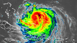
The National Weather Service has issued Storm Surge Warnings stretching from Cape Lookout National Seashore to Duck, North Carolina, where waves between two and four feet are expected. In addition, a Tropical Storm Watch is in place for coastal areas north of North Carolina extending to Chincoteague, Virginia
Meteorologists predict that Erin will accelerate as it tracks northward, moving quickly Thursday morning into Friday afternoon. The storm’s center is expected to remain offshore, crossing the western Atlantic between the U.S. East Coast and Bermuda between Wednesday, August 20, and Friday, August 22. Forecasters anticipate that Erin will weaken as it approaches Atlantic Canada late Saturday, but it is still projected to retain hurricane strength into the weekend.
Authorities are urging residents and beachgoers to remain alert. “Even if the storm doesn’t make landfall, the rip currents and elevated surf can be life-threatening,” the National Weather Service warned in a statement. Emergency management teams across the Carolinas and mid-Atlantic are also monitoring potential coastal flooding, beach erosion, and power outages as the storm continues its path.
Hurricane Erin is the fifth named storm of the 2025 Atlantic hurricane season, which experts had forecast to be more active than average due to unusually warm ocean temperatures. Officials caution that late summer and early fall often bring the most intense tropical activity, and residents are encouraged to review emergency plans and stay alert to changing forecasts.