
The Mediocre 2020
2020 was not a great year, but there were at least some upsides. Storm chasers line up for dramatic weather events, hoping to see their glimpses of the chaos, but after hearing about the complications of the Coronavirus spreading to America in early 2020, I thought that it would have been easier to storm chase and document footage. Yet, to my surprise, mother nature too would quarantine due to the dramatic shift in the climate. Covid cases grew and my patience shortened.
2019 was one of the best years for storm chasing ever. 2019 saw amazing shelves, dramatic lighting, and even a tornado all within a long period of five months. 2020 had the same things, but they were all completely spread out. I would have to wait for months or weeks to see some incredible sights. Although 2020 had more captures and a few new upgrades, nobody was prepared for how mediocre storm season was going to be in the following months.
2020 did have a booming start, with the first major outbreak on January 10th. 50 tornadoes were reported with 13 of them being EF2 rated. EF scales (Enhanced Fujita Scale) is measured by how much damage a tornado causes. About 70% of tornadoes are rated Ef0 while the much more rare EF5 happens 0.51% of the time. The last EF5 recorded was back in 2016 where a tornado ripped a house completely from its foundation. Cracks were even seen in the foundation. Initially, this tornado was going to be rated an EF4, yet after seeing the house completely removed from where it was before, its recorded 180mph winds really made the difference though.
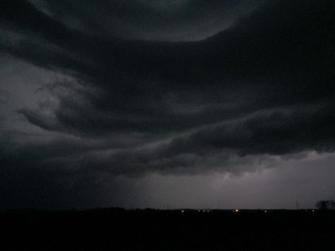
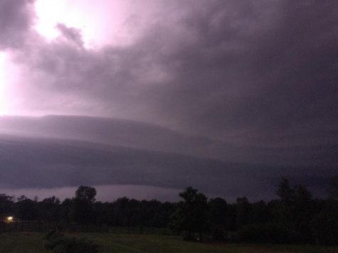
March and April saw a whole bunch of nothing. Don’t get me wrong, we had a few pulse storms fizzle in and out of existence, but it was nothing exciting. Tornado Alley would also fall silent. Normally, warm moist air and instability shears from the Gulf of Mexico, lead to storms. This combination of ingredients can create squall lines. Squall lines are considered as a linear mode of thunderstorms pushing strong outflow winds ahead of the storm. These storms can stretch hundreds of miles with mass devastation if the correct ingredients are there. Yet, tornadoes are uncommon with these sorts of complexes, but what’s more depicted is a gloomy shelf cloud instead. April 8th marked the first dangerous storm chase, with an Enhanced risk of thunderstorms and a staggering 30% for significant winds. We left our camp around sunset and traveled somewhere just a bit more open, hoping to see something as significant as the media was pressing. We waited. After five long months of silence, this storm pushed winds upward to 70 mph and caused plenty of damages to Southern Indiana.
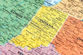
Although tornadoes are uncommon, 13/22 of the reports were tornadoes located in southern and northern Indiana, already breaking the reported average for April.
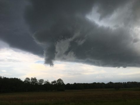
More storms following the same guidelines would trample at night, leading to some incredible time-lapse footage covering the damage that 2020 has already brought. Although, Derechos would not be the only thing to arrive. Crothersville was the spawning ground for some wicked scenery, too. A shelf cloud loomed just south of the storm, making a horseshoe shape suggesting plausible rotation. Another area of rotation was located just outside of the FFD (forward flank downdraft.) This storm was loaded with hail and strong rain, but we were lucky to avoid it. We parked on a dead-end road, waiting for something to happen; we looked everywhere. Unfortunately, we got caught in the rain while a funnel cloud was reported just miles away. We were disappointed, but many chasers have been caught in the rain and learned from their mistakes. But some people like us do not… This would be our third funnel missed.
Many nights, I would stay up watching epileptic flashes drag closer and closer toward us. Strikes slide from one end of the horizon to the other with stronger flashes behind the treeline. Some strikes would extend further away from the storm, with one sliding downward than sliding to the right. CG’s (Cloud to ground lightning) was not the show, instead, Anvil crawlers zoomed out of the storm’s updraft. Anvil Crawlers form when a Positive CG strikes and an area of negative energy gets charged, dispersing ginormous lightning discharges. Normally, Squall lines or Derechos form these types of charges.
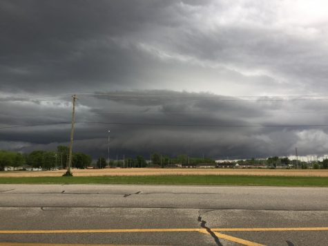
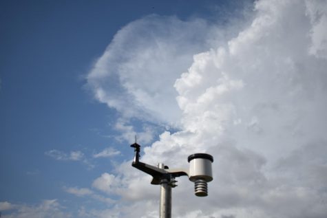
Unfortunately, July would fall silent. A few Pulse storms would form under convection and humidity, but we had to wait, again. August had one storm, which was one of the best Derechos we have ever captured. Iowa, Illinois, and Michigan were all under a Moderate Risk, which is one of the highest ratings to give. Tornadoes were not really the main issue with this storm; it was the fact that winds could have been upward to 90mph with the front. Wind reports grew, with several buildings completely destroyed and many others damaged in Iowa. Chicago was hit by a weak tornado while winds blasted some 80mph throughout the town. This Derecho stretched almost 200 miles in length before hitting us. By the time Indianapolis was struck, we departed and traveled north on Highway 31, finding an open spot that was additionally an easy escape route. We saw the front, the shelf cloud had three striations and a long whale’s mouth (underbelly of shelf cloud before the rain.) We were struck with lighter winds that only hit around 50 mph. These are very strong winds still, but not as dangerous. Darkness consumed the sky, leading to a few really good lightning strikes. We drove through the storm, which was much weaker at this point, to find out that this might be our last chase, due to the cold front being so powerful that it pushed even some instability in the ocean away from America. It would regenerate, but it would take a very long time before something good happened again. This is why October 23rd was so special.
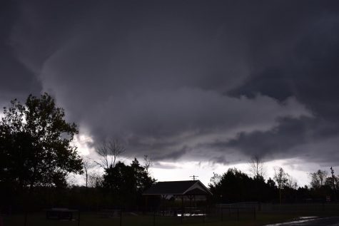
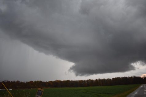
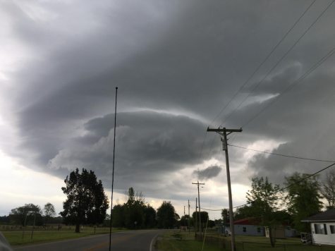
This dreamy storm chase was the main event of this year. I was aware of the conditions, but I just needed to figure out what cell to chase. I sat and waited for almost three hours, watching one cell before the sirens blared in Seymour. I rushed on the road, trying to get south of the airport. I almost missed the storm of the season due to traffic. I finally went down the strait, leading to the masculine wall cloud, churning and spinning. It would form three separate spinning layers, tripling the awesomeness. I would sit and wait for this thing to lower, yet it never did. We kept following the storm, which was tracking east, to see if anything else could happen. Yet, nothing did. To our surprise, another equally strong squadron was headed toward us, charged with hail and heavy rains. Timelapse footage showed the storm turn from a turquoise to a darker green.
Captivated by this storm, we didn’t have anywhere to hide. So, oblivious of the hail, we just drove through it. Some pea-sized hail was recorded with bigger hail seen up north. A hailstone was recorded to be 1.5″ in diameter with three separate layers inside of the stone. This is caused by a strong area of updraft located inside the storm. This updraft can reach layers where temperatures reach in the zero digits, leading to ice forming. When the ice gets too heavy, it falls. The updraft will then push it back up, giving it another layer of ice. The stone will eventually be too heavy for the updraft to sustain, which makes the hail fall.
November marks the end to this season, with snow hitting at the average time of the month and the very, very cold upper atmosphere. This year may look quite active to some of the viewers, but if you knew how 2019 really was, this paragraph would be the halfway point to the article. Four Shelf clouds and over 3000 photos of lightning were recorded this year, with all the documentation published on my YouTube channel, which will be posted below. Another storm chaser located in northern Indiana has also captured some amazing storms this year. He has also captured the infamous Kokomo tornado back in 2016. He will be featured in an article in the coming soon! So, stay tuned for that! With the vaccine rolling out, and surely some sort of relief to this harsh year, we all hope for the best. It will all be better soon. See ya next year with another Chronicle!
Youtube: https://www.youtube.com/channel/UC0jCERGoQ-5IVWawt_jNgeg?view_as=subscriber
Your donation will support the student journalists of Seymour High School. Your contribution will allow us to purchase equipment and cover our annual website hosting costs.
Hello, my name is Andrew Dickmeyer, and I am known to be "The Weatherman" of the school. I have learned tons of information on how weather works and...